State officials and major health care industry groups have agreed to a 90-day approach to address severe emergency department capacity challenges by redirecting certain patients in eastern Massachusetts to urgent care providers.
The Executive …
Your Hometown Radio
State officials and major health care industry groups have agreed to a 90-day approach to address severe emergency department capacity challenges by redirecting certain patients in eastern Massachusetts to urgent care providers.
The Executive …
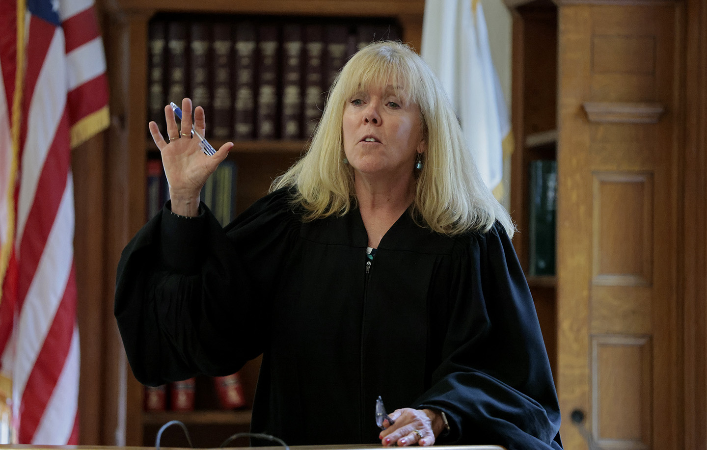
There’s still now verdict in the Karen Read murder trial.
Read is charged with second-degree murder in the January 2022 death of her boyfriend, Boston Police Officer John O’Keefe. She’s accused of dropping him off at another officer’s house party in Canton, Massachusetts, after a night of drinking, and then hitting him with her SUV and leaving him to die in a snowstorm.
Her defense team argues she was framed, and that the evidence shows O’Keefe was beaten up by someone else inside the house, bitten by a dog and left outside.
Watch the Karen Read trial live on nbcboston.com, NECN, NBC Boston streaming platforms (including Roku, Peacock and Samsung TV) and NBC10 Boston’s YouTube page. Every night of the trial at 7 p.m., come back for analysis and more.
Email questions to canton.confidential@nbcuni.com.
The jury convenes again Friday for their fourth day of deliberations — clearly taking their time to reveal all the evidence in the case before making their decision.
Any attorney will tell you no one truly knows what’s going on in a jury room. So, while many legal analysts thought we’d have a verdict by now, others say it’s not surprising the jury is going into its fourth day of deliberations.
They say there could be a multitude of factors — from a holdout for guilty or not guilty, to a group of jurors just wanting to make sure they’ve examined all the evidence and not missed anything that could sway their decision either way.
After all, this is a second-degree murder case, and juries tend to take their responsibility very seriously. Add to that, the fact that getting 12 people to come to a unanimous decision on anything can be difficult.
Criminal defense attorney Peter Elikann says after more than 70 witnesses and nine weeks of testimony, these jurors have a lot to sift through to reach a verdict.
“Keep in mind, we’ve all been talking about this case, gossiping. The jury has never been able to talk about this at all. They’re forbidden to chat about this case, and this is the very first time they’re sitting in a room, the 12 of them, and going over the evidence, and chatting. They must just be ready to explode with all this pent in them for the last nine weeks,” said Elikann.
Looking at other high-profile cases in Massachusetts, they’ve varied in length of deliberations.
For example, in the Aaron Hernandez trials, he was found guilty of killing Odin Lloyd after about 36 hours of deliberations. But he was found not guilty of killing Safiro Furtado and Daniel de Abreu in roughly the same amount of time.
Emmanuel Lopes was found guilty of killing a police officer and a bystander after a week of deliberations, and that happened after his first trial ended with a hung jury.
And Adam Montgomery, who was convicted of killing his daughter Harmony, was found guilty in just eight hours.
Suffolk University Law School professor Chris Dearborn says it’s hard to know what’s going on it that jury room, and even harder to determine whether that signals a guilty or not guilty verdict.
“One possibility is they’re just really taking this seriously. They were together for six weeks. They heard a lot of evidence. They want to get it right. And I think that’s a good sign for the system when they do that,” said Dearborn. “It’s also possible that they’re caught up on one kind of piece of evidence. There may be one or two holdouts from whatever the majority position is, and they’re trying to work all that through.”
Deliberations are scheduled to resume around 9 a.m. Friday.
Nice dry, fresh start Friday. Full sun with highs in the upper 70s make this a top 10 summer day. There will be a gentle sea breeze along the coast in the afternoon.
I’m still liking the look of most of the weekend. Saturday sees the clo…
Before voting very late Thursday night to pass a housing policy and borrowing bill that many said could turn the tides of the state’s housing market, senators adopted an amendment that would prohibit most home purchase offers that are condi…
Massachusetts 988 Suicide and Crisis Lifeline gets $8 million: ‘Lifesaving’
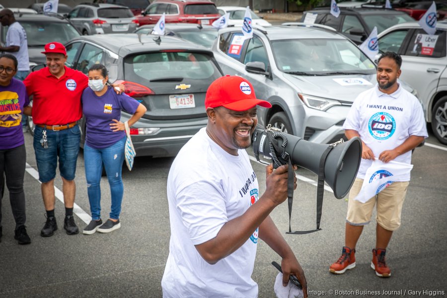
State prosecutors agreed to a settlement with Uber and Lyft that will require the companies to pay Massachusetts $175 million, increase wages for drivers and offer a range of new benefits, officials announced Thursday.
Attorney General Andrea Joy Campbell’s office said her team struck a deal with the gig economy giants that resolves a 2020 lawsuit her predecessor, now-Gov. Maura Healey, filed alleging that Uber and Lyft violated state labor laws.
The agreement will require Uber to pay the state $148 million and Lyft to pay the state $27 million, most of which will become restitution payments to current and former drivers, Campbell’s office said.
The companies also agreed to begin providing drivers at least $32.50 per hour for the time they spend traveling to pick up passengers and transporting them to their destination, which Campbell’s team said is “the first time that the tens of thousands of Uber and Lyft drivers in Massachusetts will be guaranteed minimum pay.”
As part of the settlement, Uber and Lyft agreed not to campaign for or fund the ballot question they have been seeking for years, which would rewrite state law in their favor by defining drivers as independent contractors.
Uber and Lyft officials confirmed that the company will pull its support from the measure, which earlier on Thursday survived an eligibility challenge before the state’s highest court.
It’s not clear if other companies that have backed the ballot question who were not involved in the attorney general’s lawsuit or settlement — especially DoorDash and Instacart — intend to press forward and put the measure before voters.